|
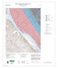
Bedrock Geologic Map, Columbia Quadrangle, Monroe and St. Clair Counties, Illinois |
34" x 41" single map sheet, contains map, legend, descriptive stratigraphic column, and descriptive text
|
Bedrock Geology |
STATEMAP |
|
Columbia |
2000 |
Joseph A. Devera |
Quadrangle |
|
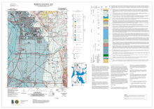
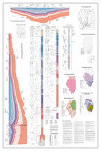
Bedrock Geologic Map, Monks Mound Quadrangle, Madison and St. Clair Counties, Illinois |
31" x 45" single map sheet, contains map, legend, descriptive text, cross section, descriptive stratigraphic column, and 2 figures
|
Bedrock Geology |
STATEMAP |
|
Monks Mound |
2001 |
F. Brett Denny, Joseph A. Devera |
Quadrangle |
|
Bedrock Geologic Map, Paderborn Quadrangle, Monroe and St. Clair Counties, Illinois |
33" x 43" single map sheet, contains map, legend, descriptive stratigraphic column, cross section, and descriptive text
|
Bedrock Geology |
STATEMAP |
|
Paderborn |
2002 |
Joseph A. Devera |
Quadrangle |
|
Bedrock Geologic Map, Renault Quadrangle, Monroe County, Illinois |
34" x 41" single map sheet, contains map, legend, descriptive stratigraphic column, cross section, and descriptive text
|
Bedrock Geology |
STATEMAP |
|
Renault |
2000 |
Joseph A. Devera |
Quadrangle |
|
Bedrock Geologic Map, Selma Quadrangle, (Illinois Portion), Monroe County, Illinois |
33" x 41" single map sheet, contains map, legend, descriptive stratigraphic column, cross section and descriptive text
|
Bedrock Geology |
STATEMAP |
|
Selma |
2002 |
F. Brett Denny, Joseph A. Devera |
Quadrangle |
|
Bedrock Geologic Map, Waterloo Quadrangle, Monroe County, Illinois |
32" x 42" single map sheet, contains map, legend, descriptive stratigraphic column, descriptive text, and cross section
|
Bedrock Geology |
STATEMAP |
|
Waterloo |
2000 |
F. Brett Denny |
Quadrangle |
|
Bedrock Geologic Map, Wood River Quadrangle, Madison County, Illinois |
46" x 32.5" single map sheet, contains map, legend, descriptive stratigraphic column, descriptive text, and 1 figure
|
Bedrock Geology |
STATEMAP |
|
Wood River |
2001 |
F. Brett Denny, Joseph A. Devera |
Quadrangle |
|
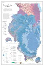
Bedrock Geology Map of Illinois |
Two 34" x 41" map sheets
|
Bedrock Geology |
|
Illinois Map Series (IMAP) |
|
2005 |
Dennis R. Kolata |
Statewide |
|
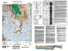
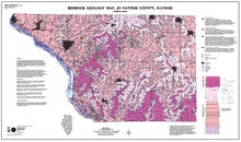
Bedrock Geology Map, Grafton Quadrangle, (Illinois Portion), Jersey and Calhoun Counties, Illinois |
33" x 43" map sheet; includes legend, descriptive text, stratigraphic column, photograph, and cross section
|
Bedrock Geology |
STATEMAP |
Illinois Geologic Quadrangle Series (IGQ) |
Grafton |
2002 |
F. Brett Denny, Joseph A. Devera |
Quadrangle |
|
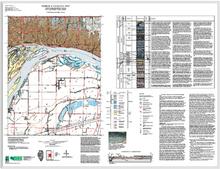
Bedrock Geology Map, Jo Daviess County, Illinois |
1:62,500 Jo Daviess County map; 49" x 29" single map sheet; includes map, legend, and descriptive text
|
Bedrock Geology |
|
Open File Series (OFS) |
|
2000 |
Christopher S. McGarry |
County |