|
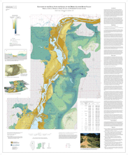
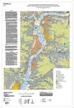
Aquifer sensitivity of the basal sand and gravel of the middle Illinois River valley, Bureau, LaSalle, Marshall, Peoria, Putnam, and Woodford Counties, Illinois |
One 40" x 45" map sheet; contains map, legend; descriptive text, and 2 figures.
|
Middle Illinois River Valley |
Aquifer Sensitivity |
Illinois Map Series (IMAP) |
2015 |
Richard C. Berg, E. Donald McKay III, Barbara J. Stiff |
|
Basal Sand and Gravel Thickness of the Middle Illinois River Valley, Bureau, LaSalle, Marshall, Peoria, Putnam, and Woodford Counties, Illinois |
One 41" x 45" map sheet; contains map, legends; descriptive text, 1 table, and 3 figures.
|
Middle Illinois River Valley |
Basal Sand and Gravel Thickness |
Illinois Map Series (IMAP) |
2015 |
Richard C. Berg, E. Donald McKay III, Barbara J. Stiff |
|
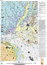
Bedrock Topography of the Middle Illinois River Valley, Bureau, LaSalle, Marshall, Peoria, Putnam, and Woodford Counties, Illinois |
One 38" x 44" map sheet; includes map, legends, and descriptive text with 2 figures.
|
Middle Illinois River Valley |
Bedrock Topography |
Illinois Map Series (IMAP) |
2009 |
Richard C. Berg, C. Pius Wiebel, Andrew J. Stumpf, E. Donald McKay III |
|
Drift Thickness of the Middle Illinois River Valley, Bureau, LaSalle, Marshall, Peoria, Putnam, and Woodford Counties, Illinois |
One 37" x 44" map sheet; includes map, legends, and descriptive text with 3 figures.
|
Middle Illinois River Valley |
Drift Thickness |
Illinois Map Series (IMAP) |
2014 |
Richard C. Berg, E. Donald McKay III, Barbara J. Stiff |
|
Elevation of the Basal Sand and Gravel of the Middle Illinois River Valley, Bureau, LaSalle, Marshall, Peoria, Putnam, and Woodford Counties, Illinois |
One 37" x 44" map sheet; includes map, legends, and descriptive text with 4 figures.
|
Middle Illinois River Valley |
Bedrock |
Illinois Map Series (IMAP) |
2012 |
Richard C. Berg, E. Donald McKay III, Barbara J. Stiff |
|
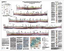
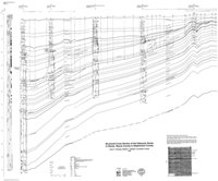
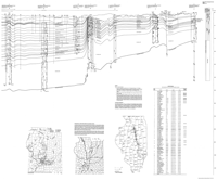
Geologic Cross Sections across the Mahomet Bedrock Valley |
One 44" x 35 " map sheet; contains 5 cross sections, 1 correlation diagram, legends, one figure, and descriptive text.
|
Mahomet Bedrock Valley |
Cross Sections |
Illinois Map Series (IMAP) |
2015 |
Andrew J. Stumpf, Lisa A. Atkinson |
|
Geologic Materials in the Vicinity of the Lower Wabash Valley Illinois, Indiana, and Kentucky |
|
Lower Wabash Valley Illinois, Indiana, and Kentucky |
Geologic Materials |
Open File Series (OFS) |
1997 |
William W. Shilts |
|
Infrastructure for Emergency Response Planning in the Vicinity of the Lower Wabash Valley Illinois, Indiana, and Kentucky |
|
Lower Wabash Valley Illinois, Indiana, and Kentucky |
Infrastructure |
Open File Series (OFS) |
1997 |
William W. Shilts |
|
Soil parent materials of the middle Illinois River Valley, Bureau, LaSalle, Marshall, Peoria, Putnam, and Woodford Counties, Illinois |
One 32" x 45" map sheet; contains map, legend; and descriptive text.
|
Middle Illinois River Valley |
Soils and Parent Materials |
Illinois Map Series (IMAP) |
2015 |
Richard C. Berg, Barbara J. Stiff, E. Donald McKay III |
|
Structural cross section of the Paleozoic rocks in Illinois, Wayne County to Stephenson County |
Two 34" x 41" map sheets
|
Wayne County to Stephenson County, Illinois |
Cross Sections |
Illinois Map Series (IMAP) |
1997 |
Janis D. Treworgy, Stephen T. Whitaker, Zakaria Lasemi |