Search for keywords in titles, authors, descriptions, and publication year below. For more detailed searches on themes, quads, series, programs, counties, and states, click the "Advanced Search" option.
Displaying 41 - 50 of 396| Map Images | Title | Description | Quads | Themes | Program | Series | Publication Date | Authors |
|---|---|---|---|---|---|---|---|---|
|
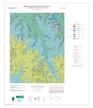
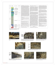
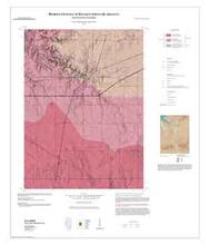
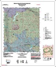
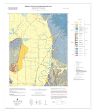
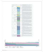
Bedrock Geology of Fishhook Quadrangle, Adams, Brown, and Pike Counties, Illinois | Two 36" x 30" map sheets and separate 3 page report; sheet 1 contains map and legends; sheet 2 includes descriptive stratigraphic column and 8 photos; report includes descriptive text |
Fishhook | Bedrock Geology | Illinois Preliminary Geologic Map Series (IPGM) | 2008 | Russell J. Jacobson , Zakaria Lasemi | |
|
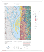
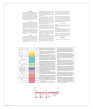
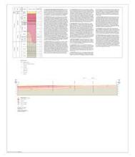
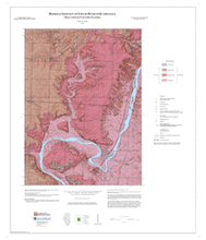
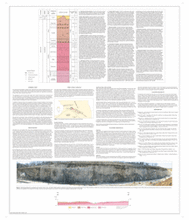
Bedrock Geology of Foley Quadrangle, Calhoun County, Illinois | Two 36" x 30" map sheets; sheet 1 contains map and legends; sheet 2 includes descriptive stratigraphic column, cross section, and descriptive text. |
Foley | Bedrock Geology | STATEMAP | 2010 | Joseph A. Devera | |
|
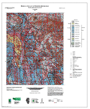
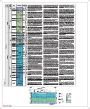
Bedrock Geology of Franklin Grove Quadrangle, Lee County, Illinois | Two 35" x 30" map sheets; sheet 1 contains map, legends and 1 figure; sheet 2 includes stratigraphic column, unit descriptions, and 1 cross section. A 24 page report includes stratigraphy, paleontology, sedimentology, structural geology, economic resources, references, 9 figures and 3 plates. |
Franklin Grove | Bedrock Geology | STATEMAP | 2020 | Franck Delpomdor, Joseph Devera | |
|
Bedrock Geology of Freeburg Quadrangle, St. Clair County, Illinois | 36" x 30" two map sheets; sheet 1 contains map and legend; sheet 2 includes descriptive stratigraphic column and cross section |
Freeburg | Bedrock Geology | STATEMAP | Illinois Preliminary Geologic Map Series (IPGM) | 2005 | W. John Nelson |

|
Bedrock Geology of French Village Quadrangle, St Clair County, Illinois | No map image available. Please contact authors for more information. |
French Village | Bedrock Geology | STATEMAP | 1999 | F. Brett Denny, Joseph A. Devera | |
|
Bedrock Geology of Galatia Quadrangle, Saline County, Illinois | Two 36" x 30" map sheets and one 4-page report; sheet 1 contains map, legends, and one figure; sheet 2 includes descriptive stratigraphic column and cross section; report contains descriptive text. |
Galatia | Bedrock Geology | STATEMAP | 2015 | W. John Nelson, F. Brett Denny | |
|
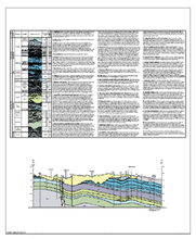
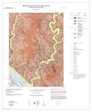
Bedrock Geology of Galena Quadrangle, Jo Daviess County, Illinois | Two 35" x 30" map sheets; sheet 1 contains map and legends; sheet 2 includes stratigraphic column with descriptions and 2 cross sections. The accompanying 9-page report includes discussions, references, and 7 figures. |
Galena | Bedrock Geology | STATEMAP | 2022 | Franck R.A. Delpomdor | |
|
Bedrock Geology of Gorham Quadrangle, Jackson County, Illinois | Two 36" x 30" map sheets and one 3-page report; sheet 1 contains map and legends; sheet 2 includes descriptive stratigraphic column and cross section; report contains descriptive text |
Gorham | Bedrock Geology | STATEMAP | 2009 | Mary J. Seid, Joseph A. Devera, Allen L. Weedman | |
|
Bedrock Geology of Grand Detour Quadrangle, Ogle and Lee Counties, Illinois | Two 30" x 35" map sheets; sheet 1 contains map and legends; sheet 2 includes descriptive stratigraphic column, cross section, descriptive text, and 2 figures. |
Grand Detour | Bedrock Geology | STATEMAP | Illinois Geologic Quadrangle Series (IGQ) | 2012 | Dennis R. Kolata |
|
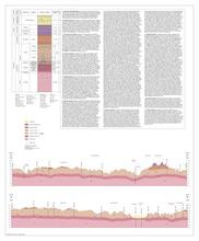
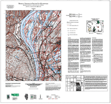
Bedrock Geology of Granite City Quadrangle, Madison and St. Clair Counties, Illinois, and St. Louis, County, Missouri | 34" x 36" single map sheet, contains map, legend, descriptive stratigraphic column, descriptive text, and 1 figure |
Granite City | Bedrock Geology | STATEMAP | 2003 | F. Brett Denny |