Search for keywords in titles, authors, descriptions, and publication year below. For more detailed searches on themes, quads, series, programs, counties, and states, click the "Advanced Search" option.
Displaying 21 - 30 of 396| Map Images | Title | Description | Quads | Themes | Program | Series | Publication Date | Authors |
|---|---|---|---|---|---|---|---|---|
|
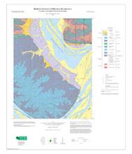
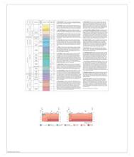
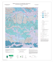
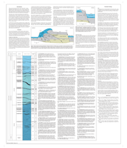
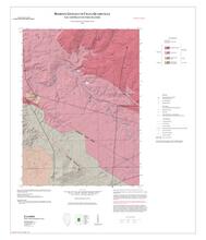
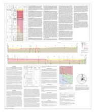
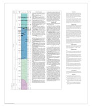
Bedrock Geology of Brussels Quadrangle, Calhoun and Jersey Counties, Illinois | Two 36" x 30" map sheets and one 6 page report; sheet 1 contains map and legends; sheet 2 includes descriptive stratigraphic column and 2 cross sections |
Brussels | Bedrock Geology | STATEMAP | 2008 | Mary J. Seid, Joseph A. Devera | |

|
Bedrock Geology of Cahokia Quadrangle, St. Clair County, Illinois | No map image available. Please contact authors for more information. |
Cahokia | Bedrock Geology | STATEMAP | 1999 | Joseph A. Devera, F. Brett Denny | |
|
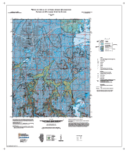
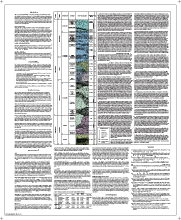
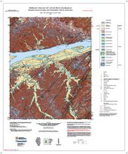
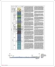
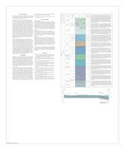
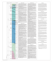
Bedrock Geology of Carbondale Quadrangle, Jackson and Williamson Counties, Illinois | Two 30" x 35" map sheets; sheet 1 contains map and legends; sheet 2 includes descriptive text, descriptive stratigraphic column, and one table. |
Carbondale | Bedrock Geology | Illinois Geologic Quadrangle Series (IGQ) | 2013 | W. John Nelson | |
|
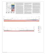
Bedrock Geology of Carrier Mills Quadrangle, Williamson and Saline Counties, Illinois | Two 36" x 30" map sheets; sheet 1 includes map and legends; sheet 2 includes descriptive text with 2 figures, and descriptive stratigraphic column |
Carrier Mills | Bedrock Geology | STATEMAP | Illinois Geologic Quadrangle Series (IGQ) | 2007 | W. John Nelson |
|
Bedrock Geology of Cave-in-Rock Quadrangle, Hardin County, Illinois, and Crittenden County, Kentucky | Two 36" x 30" map sheets and one 7-page report; sheet 1 contains map and legends; sheet 2 includes descriptive stratigraphic column and cross section; report contains descriptive text, one figure, and one appendix. |
Cave-In-Rock | Bedrock Geology | STATEMAP | 2013 | Mary J. Seid, F. Brett Denny, Joseph A. Devera | |
|
Bedrock Geology of Chana Quadrangle, Lee and Ogle Counties, Illinois | Two 34" x 28" map sheets; sheet 1 contains map and legends; sheet 2 includes descriptive stratigraphic column, 2 cross sections, 2 figures, and descriptive text. |
Chana | Bedrock Geology | STATEMAP | 2018 | Delpomdor, F., Wirth, H. | |

|
Bedrock Geology of Chester Quadrangle, Randolph County, Illinois | Two 36" x 30" map sheets; sheet 1 contains map and legends; sheet 2 includes descriptive text, descriptive stratigraphic column, and cross section |
Chester | Bedrock Geology | STATEMAP | 2006 | Joseph A. Devera | |

|
Bedrock Geology of Coal Valley Quadrangle, Rock Island and Henry Counties, Illinois | Two 35" x 30" map sheets; sheet 1 contains map and legends; sheet 2 includes stratigraphic column with descriptions and 2 cross sections. The accompanying report includes discussions, references, 9 figures and 3 plates. |
Coal Valley | Bedrock Geology | STATEMAP | 2021 | Franck R.A. Delpomdor | |

|
Bedrock Geology of Crab Orchard Lake Quadrangle, Williamson County, Illinois | Two 36" x 30" map sheets; sheet 1 includes map and legends; sheet 2 includes descriptive stratigraphic column and descriptive text |
Crab Orchard Lake | Bedrock Geology | Illinois Geologic Quadrangle Series (IGQ) | 2007 | W. John Nelson | |
|
Bedrock Geology of Crab Orchard Quadrangle, Williamson County, Illinois | Two 36" x 30" map sheets; sheet 1 includes map and legends; sheet 2 includes descriptive stratigraphic column and descriptive text |
Crab Orchard | Bedrock Geology | Illinois Geologic Quadrangle Series (IGQ) | 2007 | W. John Nelson |