General Information:
Description
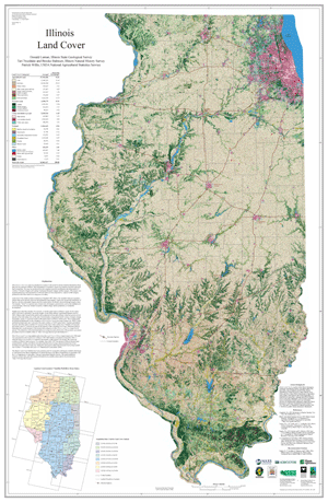
The Illinois Land Cover map was produced in resonse to the need for current, detailed information about the land, the raw material of Illinois. Such information is essential to ensure wise land-use decisions and good land stewardship. The map was produced from the computer-assisted classification and interpretation of Landsat 5 Thematic Mapper and Landsat 7 Enhanced Thematic Mapper satelite imagery. The imagery was aquired during key seasonal periods of 1999 and 2000. Analysis of this imagery produced twenty-three land cover categories.
Publication Details:
Publication Date
2004
Ordering Information