
Report Image
General Information:
Description
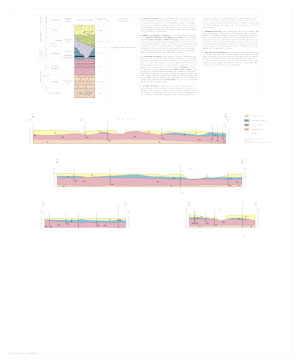
Two 35" x 30" map sheets; sheet 1 contains map and legends; sheet 2 includes 4 cross sections, stratigraphic column with descriptions. A report on the Geology of the Wedron Quadrangle with 5 photos and three figures, appendix with drill hole data and references accompanies the map.
Publication Details:
Publication Date
2021
Recommended Citation
Devera, J.A., and J.M. Krienert, 2021, Bedrock geology of Wedron Quadrangle, LaSalle County, Illinois: Illinois State Geological Survey, USGS-STATEMAP contract report, STATEMAPWedronBG, 2 sheets, 1:24,000, report, 17 p.
Map Details:
Program
STATEMAP
Theme
Quadrangles
Scale Category
Scale
Ordering Information